Select a region


The Met Office has released another weather warning for the Channel Islands, this time with an 'orange' level which indicates "light to moderate snowfall" is likely.
If the Bailiwick gets snow it is likely to start falling Monday night, with Guernsey Met tweeting that a "line of snow showers has formed in the northern part of the Channel" with forecasters expecting it to drift south.
The States of Guernsey has already issued an updated snow plan with information here about what to expect from the various public service providers if snow falls this week.
States run schools will issue notices by 07:15 on Tuesday 27 February if any are closed with the private schools making their own decisions whether to open or close based on the conditions on the day.
The emergency services will operate as normal where possible, while plans are in place to ensure healthcare staff can get to work at the hospitals to ensure those services also continue running.
Decisions will be made at Guernsey and Alderney airports based on the conditions at the time, whether it is safe for flights to operate. Aurigny has announced ways passengers can make changes to their bookings to avoid any disruption:
Condor Ferries has already cancelled the Liberation's sailings on Monday 26 February due to the strong winds expected.
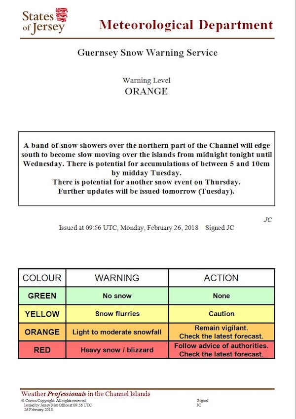
The latest weather warning was issued shortly before 10:00 on Monday 26 February, upgrading the warning from 'yellow' to 'orange' based on the latest forecast.
Further updates are expected with Guernsey Met saying it will keep an eye on the weather tonight and into tomorrow.
A line of snow showers has formed in the northern part of the Channel. We're expecting it to drift south, and we'll be keeping a close eye on it for tonight and tomorrow. pic.twitter.com/aZL1kIV3NG
— Guernsey Met (@GuernseyMet) February 26, 2018
In a statement issued to Express at 10:30 Monday 26 February the Met Office said: "a band of snow showers is already formed over the Channel, this will edge south to become slow moving over the islands by midnight. Currently it looks like it will be sat over Guernsey and Alderney. Jersey looks like it will be on the edge so may not see anything. However, it will only take a small change and we could be affected."
A yellow snow warning is in place for Jersey while the orange level snow warning covers both Guernsey and Alderney: "a band of snow showers over the northern part of the Channel will edge south to become slow moving over the islands from midnight tonight until Wednesday. There is potential for accumulations of between 5 and 10cm by midday Tuesday.
"The snow showers look likely to move away for Wednesday however, there is a significant and potentially disruptive weather system moving up from the south for Thursday. This could potentially give us heavy snow as well as strong to gale force winds. We will be continually assessing the situation as further warnings will be issued."
The Met Office said further updates will be issued on Tuesday 27 February.


Comments
Comments on this story express the views of the commentator only, not Bailiwick Publishing. We are unable to guarantee the accuracy of any of those comments.