Select a region


New guidelines have been issued for a development of up to 35 homes on another vinery site in the north of the island.
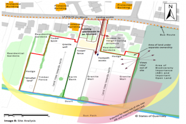
The draft development framework offers guidance on what could be built at the Cleveleys Vinery, off Braye Road, on the Vale and St Sampson's border. It could include a number of residential units including "affordable housing".
Development Frameworks are designed to offer "broad, comprehensive and practical guidance on how policies in the Island Development Plan will be applied to the site and considers the wider area and issues".
In this case, the Development & Planning Authority is now inviting comments on what could be built at the Braye Road vinery site, which lies in a recognised flood risk zone, but could be used for building up to 35 new homes. The road is already considered to be busy so any potential developers must undertake a traffic impact assessment as well as looking at landscaping.
The main guidelines are as follows:
Area must be treated as one development - The site must not be split and any development will be as one; although a phased delivery is acceptable
Large site to accomodate between 25 and 35 dwellings - The exact mix and sizes will be determined at the point a planning application is submitted
Preference to two storey buildings - Two storey buildings constitute more efficient use of land than single storey
A traffic impact assessment will be required - It is identified that such a large development will impact the local traffic network and accessibility to the site, integration with the existing traffic network and car parking will be assessed
A full landscaping scheme should be submitted as part of any proposal - It is identified that the site is low lying with an existing doubt. Any development must include plans to protect the existing landscape and enhance the area with suitable hedging and trees
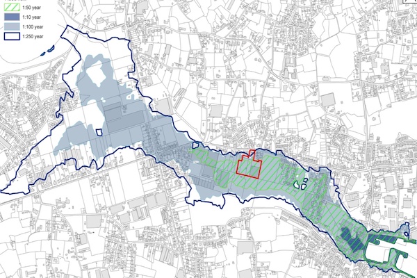 Pictured: The known flood risk zones around the Braye Road on the Vale/St Sampson's border from the Draft Development Framework for the vinery site
The full Draft Development Framework can be accessed via the States of Guernsey website or paper copies are available at the Planning Service Reception at Sir Charles Frossard House.
You can comment by 9 February, by emailing planning@gov.gg or by writing to the Authority at Sir Charles Frossard House, La Charroterie, St Peter Port. Those comments will then be considered by the Development & Planning Authority when it assesses the Development Framework before considering development proposals for this site.


Comments
Comments on this story express the views of the commentator only, not Bailiwick Publishing. We are unable to guarantee the accuracy of any of those comments.